Category Archives: Canals and Rivers

Preparing to cruise

If you have the money, and sufficient recklessness, it’s not hard to buy a large boat to live on in Europe. But if you want to take that boat along the waterways, without risk of accident, arrest, or financial disaster, there are a few steps worth considering.

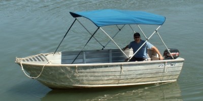
First up, it is very helpful to be or to become proficient in manouevring and being in charge of a large hunk of unwieldy metal. Plus it is a legal requirement in most places to be certified as a skipper.

We now owned… and as of July 2016 were living on… our beautiful piece of maritime history and pleasure. But we were not certified to take her anywhere, or to operate the twin radios which were a compulsory part of ship’s equipment.

And to be honest, we had no idea what would happen when we tried to handle this very large and heavy boat. We were just a tad terrified, although determined to confront our terror.

There are a couple of legal-type necessities involved. First of all, the boat needs to be registered appropriately to travel through the waterways of Europe; theoretically that could mean under the flag of almost any country, although in practice your options are limited. Secondly, the boat needs to be equipped with two marine VHF radios (one to communicate with official channels such as locks,  the other to communicate with other vesssels), and these radios need to be properly  registered as Ship Stations with their own unique IDs.

I had no idea how to go about these processes, in English let alone another language. The brokers had promised to assist but, once all the contracts – and money – had been exchanged, they faded completely from the scene.

I hit the internet and found several companies who offered the necessary registration assistance, for what seemed to me reasonable prices. I chose a Dutch firm, Yacht Registration Holland, since for reasons explained below I had decided to revert the boat’s registration to the Netherlands, her country of origin.

I sent off the necessary documents of ship specifications and ownership, and settled back to wait…. and wait….

In practice, there were only really three options for country of registration for Eben Haezer. We could not register her in France, Belgium, Germany or most other European countries since their laws permitted only citizens or permanent residents to do so.

The first option was to register her as an Australian ship, since that was the owners’ country. But that would have taken weeks if not months of to and fro correspondence between Europe and Australia, and we were eager to get moving asap. In any case, she was an inland vessel in Europe and would never get near Australia, so it seemed a bit pointless, really.

The second option was to put her on the British Small Ships Register, a relatively easy process (given Jane’s British citizenship) that would have added her to the sizeable fleet of British-registered boats cruising the waterways of Europe. But it would have meant flying the Union Jack or Red Ensign, which for me, personally, and especially after the Brexit vote of 2016, did not hold great appeal to an Aussie in Europe.

The third and best option was to enter her in a modified short form on the Dutch cadaster. The Netherlands permitted boats and owners from any country; their registry was recognised internationally; the costs and renewals were easy; and we were comfortable flying the Dutch flag on what, after all,  is a Dutch boat. And so that’s the way we went.

The same company that achieved our ship registration also handled the registration of the Ship Station for our marine VHF radios and the Automatic Identification System (AIS) which we had on board.

The AIS is a marvellous bit of kit. Every vessel over a certain length is supposed to have it, enabling the ship’s position to be tracked in real time and logged in an international database. With a laptop and the right software (such as PC-Navigo), you can also use it in course planning and tracking – watching your vessel’s progress in real time along your predetermined course – as well as “seeing” other vessels lying or approaching nearby.

This last feature is wonderful for seeing the approach of other large vessels – especially commercial barges – as you try to navigate safely on narrow waterways, and even on larger rivers. You can see the name, size and type of vessel and their speed. And you can exercise caution or avoidance as you see fit. Plus it shows you exactly where you are and how fast you are going in relation to where you are heading. All very reassuring.

There were two final pieces to fit in the jigsaw before sailing away – a skipper’s certificate and a VHF radio operator certification. The skipper qualification required a boat operator license that was recognised in Europe with an additional certification for inland waterways. The first part, if you didn’t have it already, required a practical test on an actual boat; the second part was a theory exam with a high pass threshhold. Back to the internet to find options that didn’t involve sitting for tests in French, Dutch or Flemish….

There was a lovely chap in the Netherlands who could handle all of this for us, on his boat, or he could come to us in Belgium and do it all on our own boat. Sounded great, and we lined him up. But then the Dutch holidays intervened and, with time rapidly running out, we found it impossible to get hold of him. Back to the internet ….

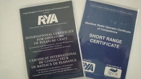
We found a boating school …. in Scotland! INDISkills, based on the Forth and Clyde Canal, east of Glasgow, could deliver everything we needed, and right now. We would qualify for an International Certificate for Operators of Pleasure Craft, with certification for Inland Waterways of Europe, as well as a Maritime Radio Operator (Short Range) Certificate of Competence.

DSC_3231

So from Schoten in Belgium we scooted off to Scotland for a week…. better yet, we were able to live on board the trainer’s boat – a lovely old English narrowboat – and turn an obligation into a pleasant floating holiday. Chrisy, our instructor/assessor, was delightful and her boat INDI was fabulous to stay on for a few days and to learn the ropes.

European Waterways

I come from a very dry country….. a very dry continent. I recall reading somewhere that the annual run off into the ocean from all the rivers of Australia is only a fraction of the run off from the Mississippi into the Gulf of Mexico. And our variability of river flows is much greater than in most other parts of the world, meaning many of our inland waterways change regularly from thirsty puddles and gurgling rock streams to raging torrents and massive floodplains.

Australian Rivers
Lots of rivers, not much water

Water storage and extraction, moreover, has always been directed to the purposes of irrigation and drinking water (and more latterly environmental flows), not for augmentation of river flows for the purposes of navigation. Not surprisingly, there has been no development of navigable canals on this continent.

Because of that, and notwithstanding some exceptions – sections of the great Murray River and estuarine environments close to the coast – for the average Australian river traveller, the “tinnie” is king. Tinnie, as you may know, is Australian slang for an aluminium dinghy… possibly powered by an outboard, often by no more than a couple of oars.

tinnie4-1
The most common form of Australian water transport

Except for a brief period in the 19th century, when the Murray and the Darling Rivers were used to transport wool and agricultural supplies, Australian rivers have never developed as reliable, integrated systems of transport, travel and communication, beyond a very localised sense.

Europe, on the other hand, has a great many reliable, navigable rivers, from the mighty Volga to the Loire, from the Elbe to the Rhone. Eighteen of these rivers flow for more than 1,000 kilometres, there are hundreds of tributaries, a network of waterways flowing into the North Sea, the Baltic, the Caspian, the Black Sea, the Adriatic, the Mediterranean, the Atlantic.

europe rivers
Water, water everywhere

Most of these watercourses enjoy climates and catchments that ensure they have fairly consistent flows, with less than a quarter of the variability of natural flows endured by Australian rivers. They are major arteries and veins of transport and communication, the catalysts for agglomerations of major cities along trade routes as well as connectors of smaller settlements to those centres and to each other. They are sources of water for agricultural production and the means to get those agricultural products to market. They are significant borders and effective means of defence, marked by major military and strategic developments going back many centuries.

Canals

The earliest canals were built for irrigation, including some astounding work by the Assyrians as early as the 7th century BC, but followed only a couple of centuries later by the Persian ruler Darius with a military canal from the Nile to the Red Sea. The Romans did a lot of it, building canals in France, Germany, Italy, the Netherlands and Britain for military transport. And you would not be surprised to hear that the Chinese were active for a thousand years in this early period in building canals for navigation and transport.

After the fall of the Roman Empire, canal building didn’t really resurface until the 12th century. At that stage canals dealt with the fall in water level primarily through stanches, or “flash locks”, which meant you just surfed your craft over a weir on a surge of water released from a reservoir. Pretty difficult, you have to admit, to get the boat back up, which led to the development of locks.

Eventually, the mitre lock was developed, enabling an expansion of canal building in the 17th century, including some quite remarkable feats of engineering which can still be seen today. The Canal de Briare was completed in 1642, connecting the Loire to the Loing (and hence the Seine and Paris). The Canal du Midi was completed in 1692 linking the Bay of Biscay to the Mediterranean.

One of the key features of these “summit” canals was that they rose on one side and fell on the other, requiring complex works to store and release water at their apexes.

Over the next century there was a burst of development of canals in France and the Netherlands, as well as in Germany.

In the 19th century the French took the lead in expanding Europe’s network of canals. The Canal Saint Quentin linked the English Channel and the North Sea with the Belgian-Dutch Schelde-Lys systems via Paris, the Oise and the Seine. The Canal de Centre connected the English Channel with the Mediterranean via the Loire. The Canal du Rhone au Rhin created a north-south route; and the Sambre-Oise canal connected the French system to the Belgian system via the Meuse River.

The effect of these developments was a doubling of the traffic carried on the inland waterways of France between the close of the 19th century and the beginning of World War II.

The Belgians also developed their canals after they achieved independence, as their mining, textile and industrial operations advanced in the 19th century, as did Scandinavia and Russia.

The coming of the modern railroad system did not really dent the usefulness of the canals in Europe, as it did in the US and Britain, because in Europe the canal networks served to connect the great rivers which were already an efficient and economical means of international transport.

Of course, as anyone who has endured a night in a cheap hotel by a railway line or ventured onto a European motorway would know, the bulk of freight today is carried by rail and road. Nevertheless, a surprising amount of goods is still transported by river and canal, sometimes by massive vessels capable of carrying thousands of tonnes.

Fortunately for recreational boaters (or plaisanciers), most of their encounters will be with far smaller craft, though still dauntingly large when they loom around a bend or approach head on in the middle of what seems an impossibly narrow canal.

The preservation of the canal system in Europe is only partially due to its continued use by a massively reduced level of cargo traffic. More important, perhaps, is the rise of tourism, which has led to a proliferation of private craft travelling the waterways, as well as an increasing number of “hotel barges”.

These three elements – the vestiges of commercial traffic, the rise of hotel barge cruising and the increased numbers of private pleasure craft – have kept the canal systems of Europe alive and functioning.

In France there are nearly 100 navigable waterways across more than 8,000 kilometres; in the Netherlands, nearly 300 waterways across nearly 4,000 kilometres; Belgium, with dozens of waterways across more than 2,000 kilometres; Germany, also with dozens of courses across several thousand kilometres.

You could travel for years, decades even, without more than a modest amount of backtracking, to see all that there is to offer in this system. And it is all – or nearly all – interconnected.

The canals of France

french canals

For many people thinking about canal cruising in Europe, France occupies a special place, romantically, aesthetically and practically. Not for nothing is it where most if not all of the major hotel barges and hire boat operators are located, and where almost all of the popular books about barging are set.

french canal scene

In one sense, it’s a little bit unfair and restrictive, because the waterways of Belgium, Holland and Germany have unique charms and great beauty. In another sense, though, there are cultural and historical reasons why this might be so.

After being a great innovator in the 17th and 18th centuries, with the development of “summit” canals requiring clever engineering and innovative lock and pound developments, France lost ground to an extent in the 19th century as river and canal navigation developed elsewhere in Europe

France, having become enamoured of its cleverness and success in developing summit canals and mitre locks, built more of them while being late to adopt the lower cost efficiencies of improving their major river systems and sea ports.

But the French did not ignore their rivers: throughout the 19th century and into the early 20th, much “canalisation”of non-navigable or unreliable stretches of several rivers was undertaken. Today, large sections of rivers such as the Saone, the Meuse, the Marne, the Yonne, the Seine and others have been effectively canalised, through bank stabilisation, weirs, in-channel locks, dredging and diversion works.

As it happened, the French system was normalised in the late 19th century to conform to a standard that was focused almost completely on local, regional and intra-national trade. This system, known as the Freycinet standard (after the public works minister who developed it) was introduced in 1879 and declared by law that all locks, bridges and other structures should conform to a strict set of dimensions.

Locks were to be 39 x 5.2 metres with a depth of 2.2 metres; bridges were to provide a minimum of 3.7 metres clearance. This standard was applied throughout the late 19th and early 20th century and beyond; by 2001 5,800 kilometres of France’s 8,500 kilometres of waterways conformed to it.

So effective was this system that it spawned the development of the unique class of vessel known as the peniche, a cargo vessel designed to  meet the Freycinet standard.

Many of these vessels can be found in France today in various states of disrepair or repair; most of the hotel barges operating on the French canals have been rescued and refurbished to high standards of luxury from this class of boat.

peniche

More tellingly, though, the Freycinet system means that two thirds of France’s waterways are capable of catering for vessels carrying no more than about 350 tonnes fully laden; yet these waterways also carry less than a quarter of the nation’s water borne traffic.

So what? Well, it means that the vast majority of canals in France, which is a very large country with a great many waterways, are closed to very large ships and carry only a smallish proportion of the total amount of shipping. Good news for skippers of pleasure craft!

There are literally thousands of kilometres of watery lanes and back roads in France, rather than superhighways, to explore the delights of cruising slowly and without purpose or pressure, and to discover small places and unexpected delights.

The downside of this – there has to be a downside, right? – is the lock. There are over 2,000 in France, compared with fewer than 200 in the Netherlands. And every lock needs to be entered, tied up in, operated and exited. Lots of work, lots of stress, lots of profanities murmured or shouted, lots of amused onlookers, and in the end inevitably, lots of painting of bruised hulls and stroking of bruised egos.

2016-09-23-15-32-23-e1491794941624.jpg
Careful, it bites!

And yet there is a design and a philosophy and a process even to this that needs to be understood and yielded to.

In the first place, a day dominated by carefully approaching, entering, waiting in and cautiously exiting locks is by necessity a slow, relaxed passage. Secondly, a day of locks almost always results in much human interaction…. with other boaters, lock keepers or bystanders. This almost never can be other than a good thing, even at its worst.

Barging the canals of France is necessarily slow. It often requires or stimulates unscheduled stops or longer stays than you anticipated. And it necessarily entails much interaction with the people along the way. Is this not how we should always prefer to travel?